Overview
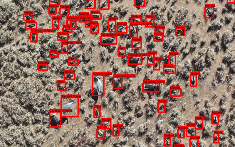
These data were collected as part of Drones for Ducks, a co-operative agreement between the US Fish and Wildlife Service and the Center for the Advancement of Spatial Informatics Research and Education (ASPIRE) at the University of New Mexico. UAS images were collected at wildlife areas in New Mexico in November and December 2018. Fifteen biologists from the US Fish and Wildlife Service annotated a twelve-image subset of UAS imagery of waterbirds collected at Bosque del Apache National Wildlife Refuge through the online image annotation platform Labelbox. These benchmark images were chosen to maximize species diversity and include a variety of vegetation and habitat types in the background.
Each observer drew polygons around individual birds and selected an identification from a list of twelve species names, which was derived from a previous survey at the site and refined via consultation with National Refuge System biologists. Anonymized observer ID is preserved in the raw annotations as “labeler_id”. This dataset includes both raw annotations and consensus annotations. To derive the consensus annotations, a Density-Based Spatial Clustering of Applications with Noise (DBSCAN) clustering algorithm was used to identify groups of bounding boxes associated with individual animals; the median coordinates of the bounding boxes implicated in each cluster were used to derive the consensus bounding box. Then, the mode species classification for each cluster was used to define the classification for the cluster to produce a consensus annotation.
Paired with these are annotations produced by volunteers using the participatory science platform, Zooniverse. Instead of species categories, volunteers labeled birds by morphological class: Duck, Goose, or Crane. Raw annotations and consensus annotations derived using the process described above are provided.
Citation, license, and contact information
If you use this dataset, please cite:
For questions about this data set, contact the Center for the Advancement of Spatial Informatics Research and Education at aspire@unm.edu.
This data set is released under the CC-BY NC 4.0 license.
Data format
The expert and volunteer datsets described above are in folders called “experts” and “crowdsourced”, respectively. Each of those folders contains a folder called “images” and two COCO-formatted .json files, one containing the raw annotations (“raw”), and one containing the consensus annotations (“refined”).
Downloading the data
This dataset is provided as a single zipfile:
Download from GCP (322MB)
Download from AWS (322MB)
Download from Azure (322MB)
Posted by Dan Morris.